Korn Seang Edouard Song imagines, designs and creates tools as artistic expressions of potential futures.
Timelines
A bus stop which treats travellers, not as passive waiting agents, but as resourceful and responsible individuals, capable of thinking, anticipating, and acting on their travel conditions.


2013
Digital image
In collaboration with Julius Heyne, Adam Jama, Alby Roseveare, Thomas Trimnell
The experience of waiting for a bus to arrive exposes the many concerns that travellers usually have about public transport: an ever-fluctuating waiting time, uncertain travelling conditions, and a self-imposed passivity.
These often result from a lack of information, only the estimated time of arrival of the next bus, suggested by a timetable or given by the countdown board, is made available.
This limited data does not allow travellers to make informed routing decisions that are expected in a multi-modal system (switch between bus routes, change mode of transportation), and reduces them to waiting machines (wait calmly for the next bus to arrive and board), disregarding their ability to think and decide.
Timelines is a bus stop which provides information to facilitate routing changes and reduce traveller uncertainty, from journey planning to boarding conditions.

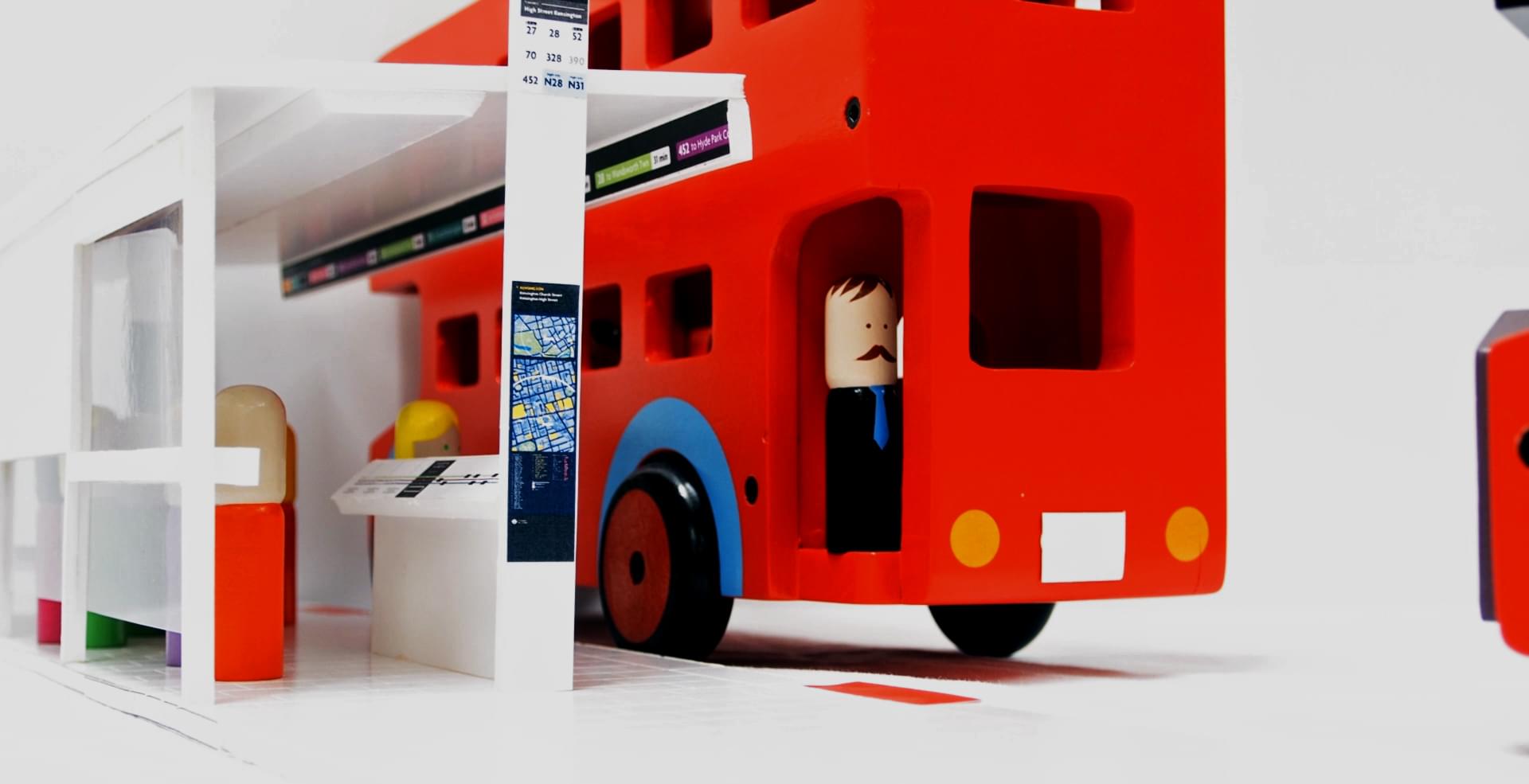
Overview of the bus stop, accompanying travellers from its entry monolith, to the dividing lectern, and the waiting area, sheltered by the roof.
Timelines can be recognized by its monolith, displaying on its front panel, general directions and served bus routes, so one can judge whether the stop is suitable for their journey.
Prospective travellers are then welcomed by a lectern, placed aside of the boarding area. This stand displays a routing map, which shows the bus routes currently serving the stop, from origin to destination, from the past to the future, from the right to the left side 1.
- 1
The routing map should indeed be read from right to left: this is natural in left-hand traffic, as vehicles move from the right to the left when one faces the street.

Right side of the routing map, showing approaching buses, with their location along their routes, and their current load.
Approaching buses are depicted individually, right on top of the served route at their real location, with their load and estimated waiting time. As the map is updated in real-time, travellers can physically see groups of buses advancing towards the stop, giving an idea of the service frequency and regularity of each line.

Left side of the routing map, showing journey destinations positioned according to their estimated journey time, alongside possible interchanges.
Route destinations are displayed on the left side of the screen, and are positioned in such a way to indicate the estimated journey time to reach them 2. Again, since the map is live, one can see destination stops moving left and right, following their varying service conditions. Lastly, the map highlights through a specfic hatch any disrupted segment along the served routes 3, both before and after the current stop.
- 2
The distance between two stop markers corresponds to the estimated travel time between these two stops: two bus stops are drawn close to each other if the journey between them is expected to be short, and vice-versa. This allows comparisons between routes that later converge towards the same stop. Here, the journey to Sloane Square will be shorter through route 72 than via line 472.
- 3
London buses have their position recorded in real-time from the iBus tracking system. Congested sections can then be identified by comparing the measured speed (using each Transport for London’s vehicle as a speed radar) to historical values.
These pieces of information help travellers reliably anticipate and picture their waiting and travelling experiences (how long their itinerary might take, how disrupted is it, will the bus be crowded…), affording them to make rational decisions about their journey (switch between bus routes, or wait comfortably…).
Once their itinerary confidently settled, travellers can calmly walk towards the busier boarding area and watch the long ticker-like screen, housed under the cantilevered roof.


Boarding information displayed on the roof screen, showing the assigned boarding zones for each bus, and a basic list of incoming buses.
This display notifies passengers, in a digestible form, of the next stopping buses, their estimated times of arrival and destination, along with the exact boarding location along the pavement, to ensure a smooth and stress-free boarding.
Timelines empowers and trust travellers to make their own informed decisions. In other words, Timelines tries to make them approach the public transport system not as passive agents reduced to waiting for their buses, but as resilient and resourceful individuals who, knowing the hurdles to their objectives, can decide, with confidence and reponsibility, to change their journey.
A small-scale version of the bus stop was modelled for exhibition purposes, and its features were successfully tested in rush-hour conditions with dedicated prototypes and mock-ups. The concept received warm interest from CBS Outdoor, and Transport for London.